")
NC Issues State Of Emergency Ahead Of Hurricane Helene
By: Rusty Wise – Wise New Network
Raleigh, NC (WNN)—North Carolina Governor Roy Cooper declared a State of Emergency on Wednesday, September 25th, 2024, ahead of Hurricane Helene.
NC Governor Roy Cooper Stated:
“Helene threatens heavy rain, flash flooding, landslides, and damaging winds to the mountains and Piedmont areas of our state. Now is the time for North Carolinians to prepare, make sure emergency kits are up-to-date, and pay attention to the weather alerts in your area.”
Threat To North Carolina
Due to a stalled front and unsettled weather, rain will fall in western North Carolina well ahead of Hurricane Helene. The rain will saturate the soil in the area, potentially leading to more fallen trees and washed-out roadways. The western counties of NC, from Cleveland and Lincoln counties westward, are currently under a Tropical Storm Watch.
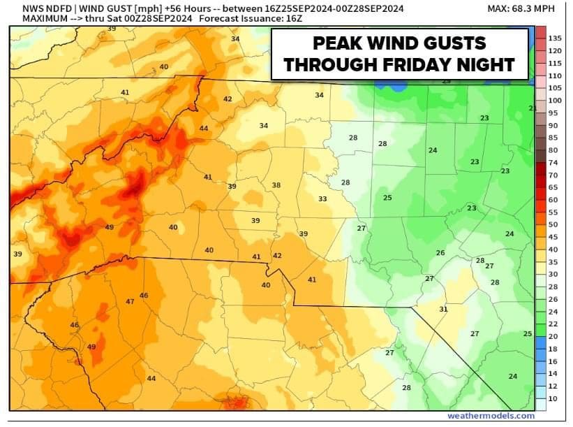
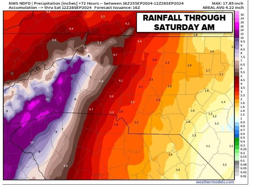
Carolinians in the Charlotte area may experience wind gusts of 40+ mph, and as you head towards the mountains, gusts may reach 65+ mph. Rainfall amounts will range from 3 inches in the Piedmont to possibly over 17 inches in the mountains. It’s important to note that any slight deviation in the hurricane’s path may result in more or less rain than forecasted.
Residents are urged to be prepared for hazards such as falling trees, power outages, flash flooding, and heavy rains. To prepare, charge cell phones, have a first aid kit and flashlights handy, top off fuel in vehicles, check generators, have drinking water and perishable food, and have a plan for pets. Avoid driving in flooded areas and stay off roads unless absolutely necessary.
Hurricane Helene
The latest update indicates that Hurricane Helene is expected to reach the US as a category 3 hurricane, potentially making landfall in Tallahassee, Florida, on Thursday morning, September 26th. A category 3 hurricane is characterized by sustained winds ranging from 111 to 129 miles per hour (mph). The projected path shows Helene passing through the Atlanta, Georgia, region, with the heaviest rainfall and strongest winds anticipated on the eastern side, significantly impacting the Carolinas.
Timeline
The most significant threat to North Carolina will occur late Thursday, 9/26, and into Friday morning, 9/27. As with any storm, lightning and tornadoes are also possible. Please check back for updates as the storm approaches and potentially changes course.
For more WNN video news stories, visit YouTube: https://www.youtube.com/@wisenewsnetwork
For more WNN articles and news stories, visit: https://wisenewsnetwork.com
Contact WNN at newsdesk@wisenewsnetwork.com
Copyright 2024 Wise News Network. All rights reserved.